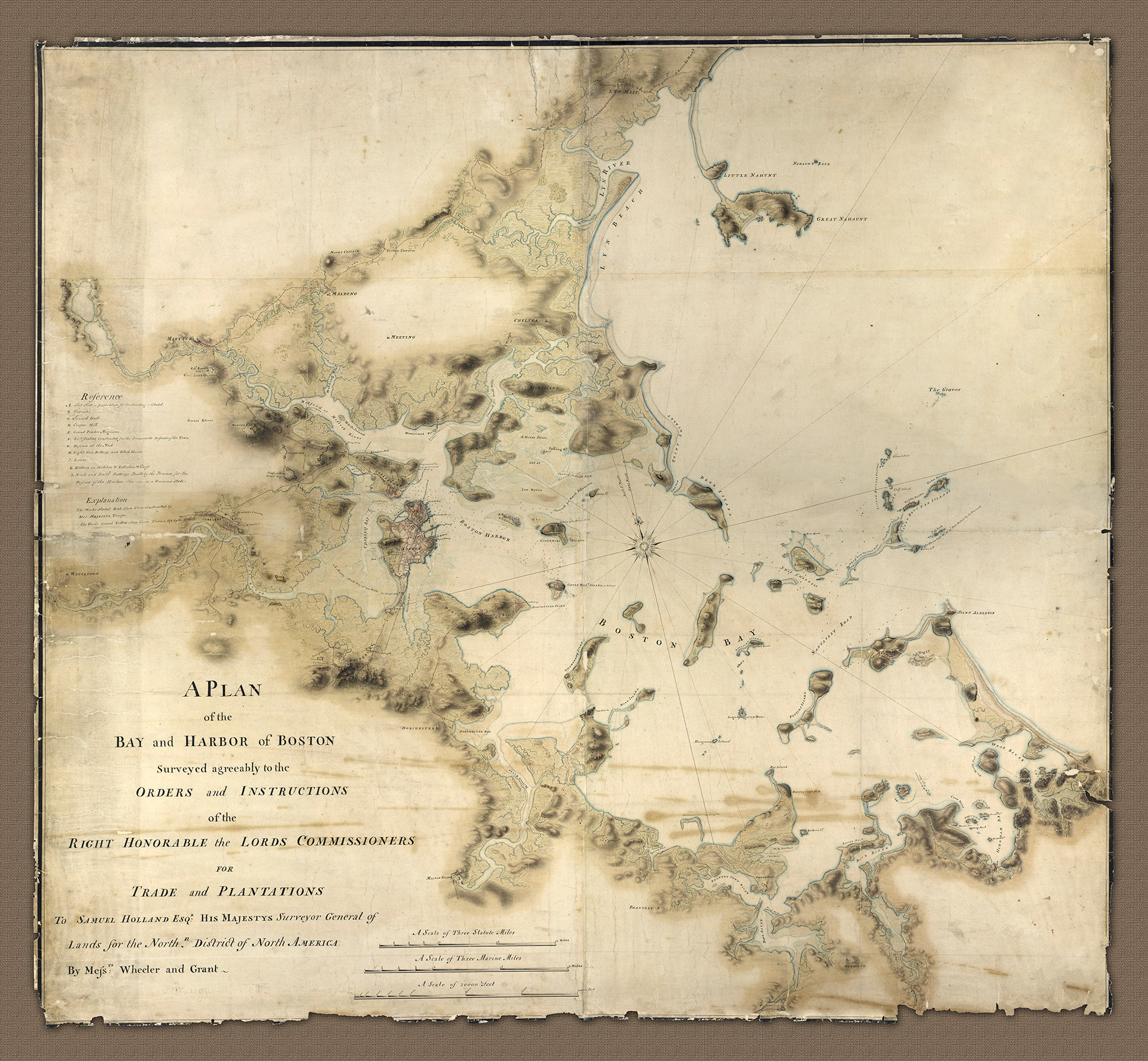
A104 - A Plan of the Bay and Harbour of Boston
This detailed and beautiful Plan of Boston and environs clearly shows the topography of the region at the time. It also includes a great deal of military disposition with the positions of both British and American forces, leading up to and including the siege of Boston in 1775 at the onset of the American War of Independence.
- 1775
- James Grant & Thomas Wheeler
- h48" x w52"
- L
The inscription on the plan reads; Surveyed agreeably to the Orders and Instructions of the Right Honourable the Lords Commissioners for Trade and Plantations to Samuel Holland Esqr, His Majesty's Surveyor General of Lands for the North District of North America by Messrs Thomas Wheeler and James Grant (Drawn by Jas. Grant? 1775). It contains a very feint pencil note under the name Grant which notes that it was drawn in 1775 and is signed in the bottom right by, possibly by Grant (although much of the signature is now lost to wear and tear).
Also shown are 'the works constructed by His Majesty's troops and those works thrown up by the Rebels' with the British troop positions in red and the positions of the American forces in yellow. military detail on the plan dates from George Washington taking command of the American Army in May 1775, through to the beaching of HM schooner Diana on the Chelsea shore north of Breeds hill and before the American occupation of Dorchester Heights which finally forced an end to the conflict in March 1776.
Amongst the detail worth noting are the location of George Washington's head quarters at Cambridge from July 1775, General Lee's quarters to the North, and General Ward's quarters at Roxbury to the South. It shows the fortification at the top of Breed's Hill as being in British hands (subsequently known as 'Bunker Hill' after the battle on June 17th 1775), as well as the point on Charlestown Peninsular where the British troops landed on that day under the command of General Howe.
Of no less significance is the inscription next to Great 'Bruster' (Brewster) Island in the entrance to the harbour which notes the destruction of the lighthouse situate there by the 'rebels' (300 American soldiers under Major Benjamin Tupper landed at the island on July 31 and burned the lighthouse down).
The siege of Boston, although not the first engagement of the Revolutionary War, proved to be a galvanising experience for the American cause. The American success was in no small part due to the ability of Washington who, although an inexperienced and often indecisive tactician and strategist, was an outstanding and motivational leader of men.
This topographical survey for this stunning plan, attributed to Wheeler and Grant is directly related to several other maps and plans of the Boston area but few are as beautifully presented.
- A Plan of the Bay and Harbour of Boston showing British and 'Rebel' positions