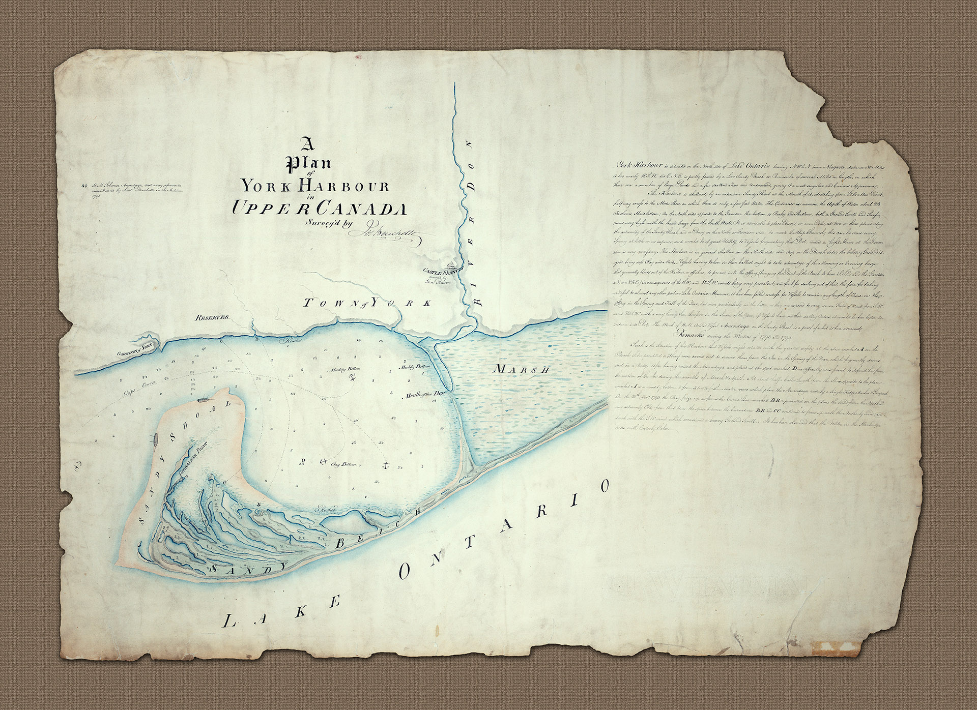
The plan makes full reference to events in 1793 and 1794 when Bouchette was responsible for surveys of the harbour. At the time this plan was drawn the settlement had less than 500 inhabitants and the town itself was little more than a military outpost although there had been settlement here for many years.
The land had been purchased from the indigeonous indians, the Mississaugas of the New Credit. Even by the end of the 1812-14 American conflict which saw the town attacked and sacked by the Americans, the population was a mere 720 in number.
Prior to the establishment of York as the capital the British had controlled their provincial operations from Niagara but that had proven vulnerable to attack from the Americans. After the war of 1812 the town expanded quickly because of its importance as the colonial capital, which attracted institutions with province-wide interests, including banks and schools. Geographically it served the commercial needs of a newly settled hinterland at a time of expanding trade and improving transportation.
Bouchette's beautiful plan includes a great deal of historic detail, which forms a part of Toronto's colorful history. His extensive remarks give a clear explanation as to why the location of the settlement was so important with its natural harbor where 'such is the situation of this harbour that vessels might winter with the greatest safety'.
His full description of the harbor also points to the location of the Garrison, which protects the harbour. Not only is the entrance narrow but there is very little room for manoeuvre for ships entering or leaving with a shallow 'hard bottom' to either side of the channel. Bouchette offers no detail of the town at the time other than to indicate where the military reserves were located and the presence of Castle Francis on the banks of the river Don. His main focus is the hydrography of the harbour.
On the plan Bouchette makes the point that 'in the Spring and Fall of the year, but more particularly in the latter as they are exposed to very severe gales of wind from S.W. and W.S.W. with a very heavy sea, therefore in this season of the year, if vessels have not their sailing Orders, it would be far better to return to Port'. By way of example, clearly marked on the plan, is the track of the His Majestey's Ship Anandada(Onagonda) which in the Autumn of 1793 floundered on the sandy shoal on the outer bank of the harbor at the hands of a young inexperienced officer.
The ship is marked by Bouchette in two places, first where she struck and secondly where she, presumably, drifted to. Bouchette is, mainly through his own offices and later accounts, credited with refloating the Anandaga and then anchored her where she 'rode by a single kedge-anchore & grapnel in the safety of the anchorage' (marked A on the plan). He reputedly received a promotion for his actions.
This historic plan of the town of York, which after the war of 1812 became Toronto. It was drawn by Joseph Bouchette, the Admiralty surveyor of the Great Lakes at the time when it was already the capital of Upper Canada, as designated by John Grave Simcoe, the then Lieutenant Governor of Upper Canada. The plan makes full reference to events in 1793 and 1794 when Bouchette was responsible for surveys of the harbour.