A502 - Lake Erie
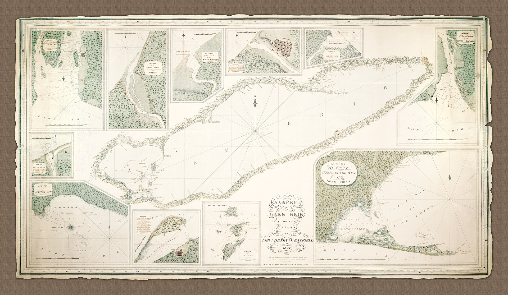
- This beautiful hand-drawn survey of Lake Erie with insets of important harbours and bays around the shoreline chart is in the hand of Mr. George Alexander Frazer but the survey itself is the work of Henry Wolsey Bayfield and his team.
- 1817-1818
- Lieu. Henry Bayfield RN
- h32" x w55"
- L
Lt.Henry Wolsey Bayfield (later Admiral) is revered, even today, for his dedication to surveying the Great Lakes region of Canada and the United States as well as for his attention to detail. The artistry included in the chart presented here almost belies the suffering which Bayfield and his deputy, Philip Collins (Midshipman), had to endure in the making of it, and many of the other surveys they completed.
According to his own diary notes the survey team frequently had to endure 'clouds' of 'moschettoes' at the west end of the lake, along the Detroit river (Heritage Charts A501) and up in to lake St. Clair (Heritage Charts A512). Poor diet, inclement weather and sheer loneliness were also factors.
Bayfield completed the survey of the north and south shore of Lake Erie and of the shoreline of Lake St. Clair and the St Clair River in 1817. Malaria was a constant threat and at one point Bayfield was forced to have two weeks off work in Amherstburg to recover from an attack of 'ague'.
The chart has no less than ten insets of harbors and towns around the coast of the lake. These are (clockwise from top left):
1. The mouth of the River Detroit with Amherstburgh with many soundings up the river.
2. A Sketch of a Small River ten miles to the Westward of Buffalo which includes the location of a (likely much needed) Tavern.
3. A sketch of the mouth of the River 'Segnan' with notes on the ever shifting sand bank or bar.
4. A Sketch of the mouth of the 'Cayanoga' River with the village of Cleveland and several other buildings.
5. A Survey of Miamis Bay.
6. A Survey of the entrance of the River Niagara which shows a current of five and three quarts miles per hour along with numerous soundings, General Porter's house [1] along with Fort Erie and the town of Buffalo.
7. A Survey of the Inner and Outer Bays of Long Point; A Survey of 'Put In Bay' and the Adjacent Islands with detailed soundings.
8. A survey of Put In Bay and adjacent Islands
9. A Sketch of, with detailed notes on the American Naval depot located there and 'Presquisle' (Presque Isle) Harbor and the Town of Erie itself.
10. A Survey of Mohawk Bay with detailed soundings.
11. A sketch of Grand River with a note that the river is 'sometimes shut by the waves' along with some buildings.
Many of the insets include distance scales in either; feet, yards or miles as appropriate. What stands-out above all else on this survey is the detailed depiction of the trees along the shores and the beautiful layout of the chart as a whole. The original colors are vibrant and the detail even goes so far as to record a 'shout reported near this place' just above the tiny island of East Sister at the Western end of the lake SSE of the entrance to the River Detroit.
The overall survey of the Great Lakes region was instigated by the British in (late) response to the war of 1812-14 between the British and Americans. The war had been fought for a number of reasons including; British interference with American shipping, the seizure of American sailors, trade restrictions with France, with whom Britain was at war in 1812, and British support of Native American land claims which were limiting European American expansion. Much of the war was fought in the Great Lakes region and indeed at the naval battle of 10 September 1813, on Lake Erie nine vessels of the United States Navy defeated and captured six British naval vessels. This ensured American control of the lake for the rest of the war, which in turn allowed the Americans to recover Detroit and win the Battle of the Thames, which in turn enabled them to break the Indian confederation of Tecumseh. It was one of the biggest naval battles of the War of 1812 and one of the British navy's worst defeats to that date. The American commander Master Commandant Oliver Hazard Perry instantly became a National hero.
[1]. Porter served as the Quartermaster General for the New York State Militia in 1812 and later in 1828 as the US Secretary of War
- Lake Erie