NZ100N - A Chart of Part of New Zealand (North Island)
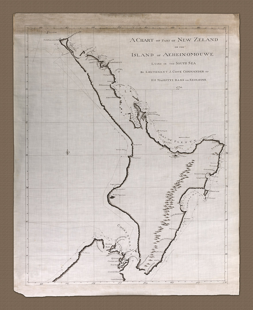
The Island of AEHEINOMOUWE (North Island). The full title of this beautiful chart, reads 'A Chart of part of New Zealand or the Island of AEHEINOMOUWE lying in the South Sea by Lieutenant J. Cook, Commander of His Majestey's Bark The Endeavour. 1770'. It was produced on Cook's return from this first voyage to the southern seas in 1768-71.
- 1770
- James Cook
- h47.5" x w38.6"
- P
The chart is made from dozens of surveys made over the course of six months by both Cook and members and his crew aboard the Endeavour. Ideally it should be studied alongside his journals which give a wonderful insight into the experiences and thoughts behind the voyage. It is one of two such charts, the other showing the South island (Heritage Charts NZ100S), part of which is included here.
In this 'age of discovery' it was common practice among British surveyors to give English names to settlements, islands, rivers, harbors and other navigable features. For Cook to retain the native Maori name 'AEHEINOMOUWE' for this, the North Island, is a clear mark of respect shown by him. It remains however one of less than half a dozen such reference to indigenous culture included. He does the same on his chart of the South Island (NZ100S).
Included on this chart, around the entire coastline, is the track of the Endeavour as it explores the coastline, complete with significant soundings taken on the way. The chart gives little information as to in-land topographic or geographic detail, other than the indication of mountains. Rivers, forests and settlements are not marked simply because it was Cooks mission to survey the coast looking for safe harbor, settlements, fresh water and sustenance, not the interior.
On the 8th of October 1769 he made his first observation of a bay he would later name 'Poverty Bay'; 'We saw in the Bay several Canoes, People upon the shore and some houses in the country. The land on the Sea-Coast is high with steep clifts and back inland are very high mountains the face of the Country is of a hilly surface and appeares to be cloathed with wood and Verdure (lush green vegetation)'.
Of his first encounters with the natives of the Poverty Bay, on the 9th October, Cook records at the end of his journal entry for the day, after a particularly unwelcoming reception upon landing which left at least two natives dead from musket fire from Cooks men, that; 'Finding that nothing was to be done with the people on this side and the water in the river being salt I embarked with an intent to row round the head of the Bay in search of fresh water; and if possible to surprise some of the natives and to take them on board and by good treatment and presents endeavour to gain their friendship'. And so the New Zealand adventure began, much as it had started on the voyage south through he South Pacific Islands.
Knowledge of how to record Latitude was at the time quite accurate and, by way of example, Cook places Cape Pallisser at Latitude 41° 30"S, which compares well with today's satellite position of 41° 59'S. Fixing Longitude in 1769 however was still in its infancy but Cook shows a great deal of accuracy on his chart by placing it at 183° 57"W (176° 03"E) Longitude compared to an actual fix of 175° 3"E. Overall, this translates to a potential navigational error of about 37 nautical miles, which is about as good as it gets for the day.
It had taken Cook nearly 6 months to complete this survey starting from his first sighting of land on the 7th October 1769, until the decision was made to sail west to reach New Holland on the 31st March 1770.
- A Chart of Part of New Zealand (North Island)