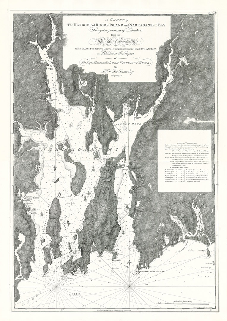
A106 - A Chart of the harbour of Rhode Island and Narragansett Bay
Taken from a 1947 'pull' from J.F.W. Des Barres' original copper this stunning plate black and white chart appears as it would back in 1776. It details precise notes and markings depicting the movements and engagements of British and French Ships between 29th July and 9th August 1778.
- 1776 & 1781
- J.F.W. Des Barres & Charles Blaskowitz
- h45" x w32"
- P
Like all other charts included in the Atlantic Neptune Folios the land topography included on this chart was surveyed 'in pursuance of Directions from the Lords of Trade to His Majesty's Surveyor General for the Northern District of North America..' This particular chart was published ' at the request of The Right Honourable Lord Viscount Howe by J.F.W Des Barres Esq.' on the 20th July 1776. The original land survey for this chart was undertaken and completed by Charles Blaskowitz and (likely) Thomas Wheeler, under instruction from Samuel Holland. The chart is also very similar, topographically, to an earlier c1775 map, by either Blaskowitz or Wheeler (see Heritage Chart A105) It is also very similar to William Faden's 1777 chart of the bay of Narragansett.
The British, under Admiral Howe, fought with the French, under Admiral D'Estaing, in the days leading-up to their landing on Rhode Island. With the British ensconced in New York, the American leadership and their French ally had made the decision to deploy fresh forces in Rhode Island and to expel the British from there. Strategically, this would trap the British forces that had occupied the region since 1776 and would open up Narragansett Bay for American and French forces, and deny the harbour and port to the British.
As American and French intentions became clearer, British General Robert Pigot set-up to defend Newport by levelling orchards and houses to provide a clear line of fire. He also had carriages and wagons destroyed and moved all livestock into the town of Newport. The American Continental Army, along with local militia in the region under John Sullivan (supported by Generals Nathanael Greene and Lafayette), and their French allies, engaged the British at the Battle of Quaker Hill on the Island of Aquidneck (Rhode Island). It was a unique occasion in the Revolutionary War, in as much as it was the only engagement fought during the war in which black Americans participated as a distinct racial group.
The battle ended inconclusively and the whole effort was undermined by the loss of the French fleet which, carrying reinforcements, was forced to withdraw to Boston for repairs due to hurricane damage. Within days of landing it was clear that the Americans would have to give up its goal of capturing the island and securing Narragansett Bay for American and French ship traffic. By the 29th of August the Americans were in retreat, leaving the British in control of the region until their final withdrawal in 1783.
Other actions were fought at numerous locations and involved sea-land bombardments. The sharpest engagement took place on August 29, with the First Rhode Island Regiment distinguishing itself by fighting off an attempted British flanking action.
The overall effect of this print is that it appears as quite modern with the stark black and white contrasts. albeit infused with historical detail.
- A Chart of the harbour of Rhode Island and Narragansett Bay