After the war of Independence Knight served with distinction across the world and in 1800 he was set the task of surveying the entrance to the French naval base at Brest. His subsequent survey caused Admiral Sir John Jervis, Earl St. Vincent to pronounce him to be 'the most accurate [surveyor] in His Majesty’s service'.
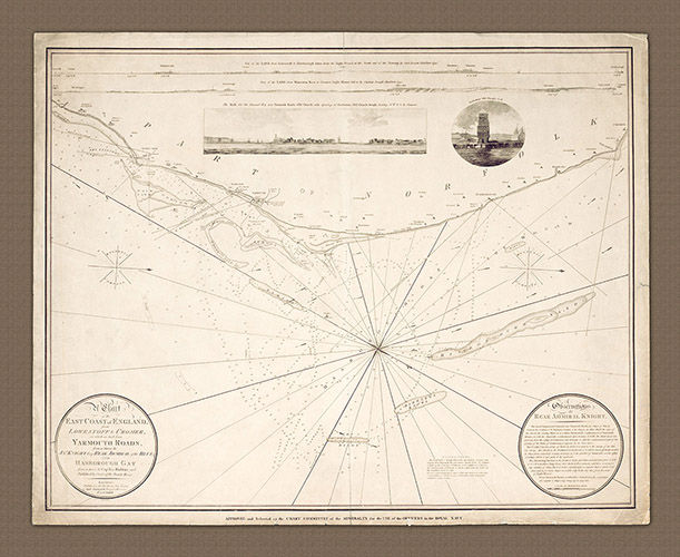
The chart presented here of the Norfolk coast is beautifully balanced between hydrographic and cartographic detail. Knight and Huddard include detailed soundings, tides, sand banks, shoals, rocks, anchorages and they also also provide lead-lines to set points on the coastline such as towers, lights and church steeples. At the top of the chart are two extended views of the coastline which exactly match the hydrographic detail so that we may see what may be seen from the ship. There are also a couple of engravings which show the the Channel Way approach into Yarmouth Roads along with another engraving of Gorleston old church steeple, for good measure. Two 'magnetic' compasses are also included on the chart with North to the right.
The land features included are of course the coastal towns along the coast from Lowestoft to Cromer including Gorleston, Yarmouth, Hasborough, Mundesley and Foulness. It reads like a guide to some of the best fish and chip shops in the UK!
Knight served on the Victory (prior to Nelson) and was promoted to Rear Admiral in 1801, the year of the making of this chart. After the Battle of Trafalgar, he was promoted once again, this time to the rank of Vice-Admiral. His final promotion; to the rank of Admiral came on the 4th December 1813.