A201 - Plan of the City of New York in North America
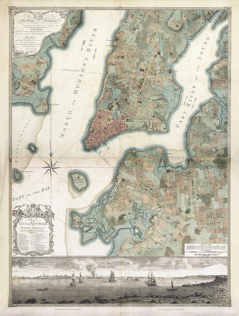
This beautiful plan drawn by Bernard Ratzer of His Majesty's Royal American Regiment and engraved by Thomas Kitchin is one of the better-known images of New York from this period, showing extensive detail of the colonial city as then was.
- 1776-1777
- Lt. Bernard Ratzer
- h48.5" x w37.5"
- P
The original survey for the portion of the chart depicting lower Manhattan was completed by Bernard Ratzer as early as 1767 and was published in 1769 on a single sheet. Unfortunately the engraver, Thomas Kitchen, misspelt Bernard Ratzers name inscribing 'Ratzen'. That plan has forever since been known as the 'Ratzen Plan'.
In 1767 Ratzer extended his original survey to include part of Brooklyn and Long Island, along with part of East shore of the Hudson and Paulus Hook. The first edition of this plan which is generally referred to as the 'Ratzer Map' was first published in 1770. The seond edition, presented here, dates from 1776.
The plan offers a superb amount of detail and lists principle buildings such as forts, churches, meeting houses, markets, colleges, barracks, powder stores etc. It also includes several interesting and revealing features of New York at that time. The decorated title cartouche references the importance of New York as a trade centre within the colony, showing a colonist and a Native American surrounded by the accoutrements of the fur trade. Inevitably there are some annomolies contained within the plan such as the fact that Delancy Square was never built and only included by Ratzer as aprojection. Also the exclusion of the name of the African American burial ground which was located just north of City Hall, which is named on other maps of the period. Finally, the inclusion of the memorial (to General Wolfe), next to the Delancy estate, on the east side even though it had been removed before 1776.
Other interesting features include the fresh water pond, which was near present-day Foley Square and was then a source of drinking water; ' Bowry Lane', is identified as the "Road to Boston," because it was part of the Boston post road running north to the top of the map. Toward the east can be seen the farm belonging to " Rutgers" or Henry Rutgers, a local philanthropist who later made a large donation to Queen's College in New Jersey, which was subsequently named after him. In addition, a number of individual landowners are named in their lands, among them is the Stuyvesant estate facing the East River. The Statue of Liberty now stands on 'Bedloes or Kennedy Island' and ' Bucking Island' is now Ellis Island.
The American Commander-in-Chief, George Washington, made his headquarters in No.1 Broadway, a magnificent town house just behind the Battery on the southern tip of the island, prior to the British landing. By the time this second state of the plan was rereleased by publishers Faden and Jeffreys 1776, fighting had broken out between patriot groups and the British. On the 21st of September, one week after the British troops first landed on Manhattan, a fire broke-out destroying about one quarter of the city. Arsonists were blamed but few were held responsible. The likelyhood is that the fire was set by American troops vacating the city.
The accompanying view is by Thomas Davies, who was an instructor in topographical drawing at the Royal Military Academy at Woolwich in England. The view is drawn from the vantage point of Governor's Island and extends from the Jerseys on the left, to Manhattan from the Battery to Corlear's Hook at the centre, with the Long Island shoreline at the right. It offers an intriguing view of what the southern-most tip of the city looked like on 12th July 1776.
Before 1776, the civilian population of New York city was about 20,000 in an area less than a square mile and it was the second largest city in Northern America. A decade after the historic conflict, New York emerged as the first capital of America, and was the scene of the George Washington's inauguration as the first President. By this time, the population had risen to 60,000.
- The Ratzer Map of New York